Na Pomezí Caves - characteristics
JESENÍK KARST
The Jeseník Karst could be said to be a simplified name for the series of big bodies and smaller islets of crystalline limestones – marbles rising from folded complexes of metamorphic rocks and plutonic magmatites of geological units of the region of the Lužické Mountains and the Moravian-Silesian Region in the Králický Sněžník Mountains, the Hanušovická Highlands, the Hrubý Jeseník Mountains, the Rychlebské Mountains and the Zlatohorská Highlands of East Sudetenland in Northern Moravia. Numerous underground and surface karst phenomena, predominantly dolines, ponors, seepages and even caves were formed in local limestones. In total, there are more than 100 caves and abysses in the Jeseník Karst.
NA POMEZÍ CAVES
- They are formed in the lens of crystalline limestones in the northern part of the karst of the Branná area, between the villages of Lipová-lázně and Vápenná at the foot of the Smrčník Hill.
- They comprise the longest cave system formed in crystalline limestones (marbles) in the Czech Republic.
- The two-level system of fissure corridors and chambers was formed by gradual corrosion of atmospheric waters and underground streams.
- They were discovered in 1937, but most of the areas were not penetrated until 1949. The caves have been open to the public in the present extent since 1955.
- The total length of all the corridors known today is 1320 m with denivelation of 47 m. Together with the neighbouring cave Liščí díra (Fox Hole) they form a system with the total length of 1,760 m.
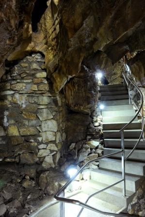
- The cave tour is 390 m long and the tour duration is 45 minutes.
- Air temperature in the caves is 7–8°C (ca 46°F), relative air humidity ca. 95%.
Evolution of the Caves
DEVELOPMENT OF THE NA POMEZÍ CAVES
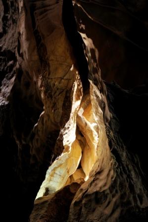
The Na Pomezí Caves are the longest and most extensive karst system formed in crystalline limestones (marbles) in the Czech Republic. The high chemical purity of the crystalline limestones, favourable inclination of beds and substantial tectonic jointing with several variably oriented systems of fissures and faults were the most decisive factors for the development of the caves. The location of these limestones above the base level of erosion was also an important factor.
Karst processes forming the Na Pomezí Caves started in the Tertiary, in a period of rainy, warm to subtropical climate. Seeping water with its corrosive and erosive activities widened cracks in limestones and created the first sections of fracture caves, which gradually joined together, countersunk, formed contiguous trails for underground streams, and in this way they could be more quickly expanded to larger cave areas. At the beginning of the Quaternary the development of the cave system was also influenced by cooling and by arrival of ice periods (glacials). Frost penetration of the limestone massif occurred – it was torn by ice in cracks, in some parts to a depth of 20 m. Full disintegration of limestone beds and breakdown of blocks occurred at higher levels of caves and lower levels (e.g. Královský dóm [Royal Dome] and Dóm chaosu [Dome of Chaos]) were buried.
Two significant levels are known in the caves. The upper level is disturbed by weathering; the lower one has preserved signs of sculpting by underground streams. The contour system documents that caves developed in dependence on recession of the Vidnávka River valley. High fissure corridors that are at several places of crossing of tectonic zones widened to dome-like spaces formed there.
It is also remarkable that some forms and shapes of the Na Pomezí Caves show characteristics known in high-mountain karst areas. The polygenetic and polycyclic development is documented by the whole process of development and variety of cave shapes.
The Na Pomezí Caves are not an isolated cave system, but part of the so-far little-known karst underground running through the limestone massif of the Smrčník Hill (798 m a.s.l.), where ten caves have been registered so far and others have been destroyed in the local quarry during mining for limestone.
PARTS INACCESSIBLE TO THE PUBLIC AND NEARBY CAVES
From the total length of 1,320 m of the underground system of the Na Pomezí Caves, 450 m is adapted and only 390 m is the length of the tour opened to the public. Other cave areas cannot be added to the visitor route since they are highly rugged, narrow profiles of the corridors are too complicated in some parts and there are also great differences in elevations. Any attempt to make them accessible would destroy them. In 1999, detailed photo documentation was prepared by workers of the cave administration. It illustrates the diversity and multiplicity of forms of stalactite and stalagmite decoration in areas that were not made accessible.
In the proximity of the Na Pomezí Caves there are nine other smaller caves which altogether form one genetic complex and hydrological system. The deepest parts of the mentioned Rasovna Cave are at a distance of only 20–25 m from the corridors of the Na Pomezí Caves. In 2008, cavers of the Czech Speleological Society from Jeseník already discovered the connection with the cave called Liščí díra on the other side of the system and crawled through it. Thus, the total length of the cave system is known to be 1,760 m so far.
In the Liščí díra Cave speleologists discovered the biggest cave area of this karst region, Rumový dóm (Debris Dome) with an area of 40 x 20 m and height of 15 m, with extraordinarily rich stalactite and stalagmite decoration and with the biggest sinter column of this region, with a height of 7 m. Interconnection with a nearby 15 m long shaft cave called Netopýrka can also be expected. It is however supposed that the main key to the whole underground karst system of the Na Pomezí Caves is Smrčnické propadání (Smrčník Sink). A half-blind valley is situated in the forest above the caves where a brook running from the slopes of the Smrčník Hill disappears into the clayey debris. Dye tests proved that after flowing through so far unknown floors of the cave system, after only 1 hour water seeps into the karst springs 61 m lower, in the valley of the Vidnávka River. If you want to get through Smrčnické propadání to the underground, you have to excavate a deep blind shaft in unstable debris where water flows through. In the 1970s, the 20 m deep blind shaft made by speleologists from the Homeland Studies Museum in Olomouc was destroyed by a single flash flood.